In a world hungry for sustainable solutions, Namibia's HyIron has fired up a game changer - producing "green-hydrogen" and using it to refine iron ore.
The Oshivela pilot project, near Arandis in the Erongo Region, is not only a first for Namibia but a world first in carbon-free iron production (see photo in background).
🔗 Try Demo (External Link - may take a few seconds to load)
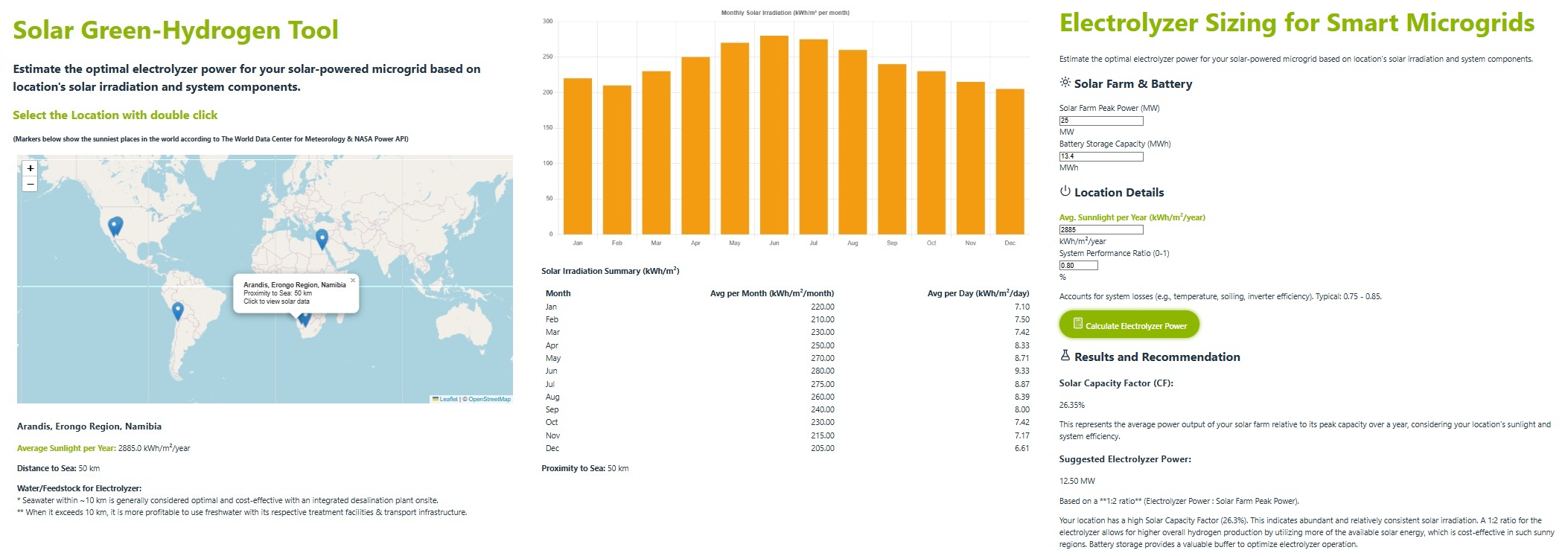
With a solar-powered facility and cutting-edge hydrogen technology, this project uses hydrogen for processing iron oxide (from the desert) to produce direct reduced iron (DRI), a crucial component in sustainable steel production. The facility operates only during day time hours, supported by the 25 MW solar farm (44.000 solar panels across 25 hectares) 13.4 MW of battery storage capacity and using a 12 MW electrolyser unit.
This web solution is designed to assist engineers and planners in evaluating the solar potential of a location and sizing hydrogen electrolyzers for smart microgrids. This project is divided into two functional parts, built step-by-step using modern tools and real-world data sources.
Part 1 - Solar Irradiation Calculator: Interactive Leaflet Map for selecting any global location. Real-time solar irradiation data from NASA POWER API. Visualizations with: Average Solar Hours per Month, Daily Solar Irradiation over 12 Months and Distance to the Coast (km) and to the Nile River (Egypt locations) using OpenStreetMap Overpass API.
Part 2 - Electrolyzer Sizing Tool for Smart Microgrids: Sizing the electrolyzer using capacity factor and ratio options with the inputs; solar farm power, battery storage capacity and its site-specific irradiation data (from Part 1).
A tool for engineers and designers to:
✅ Evaluate the solar potential of a location.
✅ Size a smart microgrid with the solar farm power and its battery storage capacity.
✅ Size hydrogen electrolyzers for smart microgrids.
⚙️ Frontend: React, Vite, Leaflet, Chart.js and Bootstrap.
⚙️ Backend: Flask (Python), NASA POWER API, Overpass API de OpenStreetMap and OpenStreetMap with Leaflet.